El Chalten - Mt Fitz Roy and Parque Nacional los Glaciers

Having left the southern ice fields and fjords behind in Chile we journeyed north through the pampas. With its wide open landscape, windmills and sheep it was easy to forget that we were not in Australia. Only the occasional herd of guanaco and odd gaucho astride a horse reminded us that we were now in Argentinian Patagonia. Our destination was El Chalten, a tiny town at the foot of the Southern Patagonian Ice Field and the self proclaimed hiking capital of Argentina.

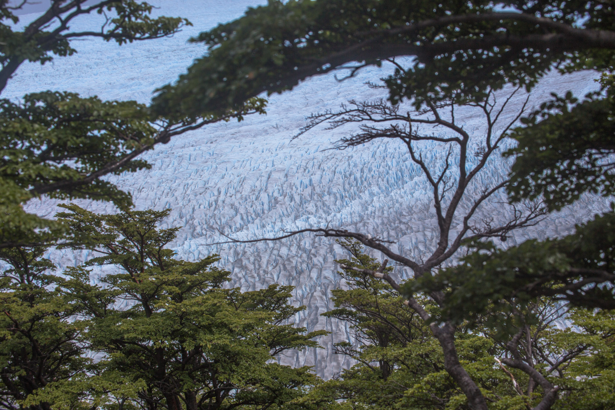
Hiking through the trees on the first day. The Fagus are just starting to turn colour in some areas.

The landscape here seems to contradict itself, the dry dusty ground offers little nutrients to the low and thorny scrub that covers the plains yet is periodically interrupted by large rushing veins of milky blue glacial melt water seemingly in a hurry to escape the mountains. As we drew closer to our destination the light was fading and through the pink haze of sunset the unmistakable peaks of Fitz Roy and Cerro Torre appeared to glow. The town itself is nestled in a valley at the foot of the mountains and is at the mercy of the winds they create.

This region forms the northern most reaches of the Patagonian ice sheet and the Parque Nacional los Glaciares. We were delighted to learn that in a rare gesture of generosity there is no park entrance fee and all camping is free. Having surveyed the hiking options in the area we decided on the classic triangle hike, which over three days allows good views of the mountains and their accompanying glaciers. That is, if the clouds threatening to hang around all week miraculously cleared. Nevertheless, kitted up we begin the first day's hike bouncing with comparatively light packs (see Torres del Paine). The path leads us up a steady but steep slope for about 6km and as the day heats up so do we. Reaching the first mirador we are disappointed with the cloudy sky and do not linger. Tired and a little dejected we stop briefly for lunch only to find its is but a short way further to the second mirador. Here we are delighted with our first cloudless view of the mountains. A crystal clear creek cascading down the slope and a view of the path winding down to the valley bellow lifts our moods. We are treated with spectacular views for the remainder of the walk to the campsite, arriving in the early afternoon just as clouds once again close in on the mountains above. From the campsite there is the option of two side trails, one climbs steeply to a mirador, the other promises a more leisurely walk to a nearby glacier and it's resultant lake.

'A pleasant 45min walk to the mirador overlooking the glacier'... *cough*

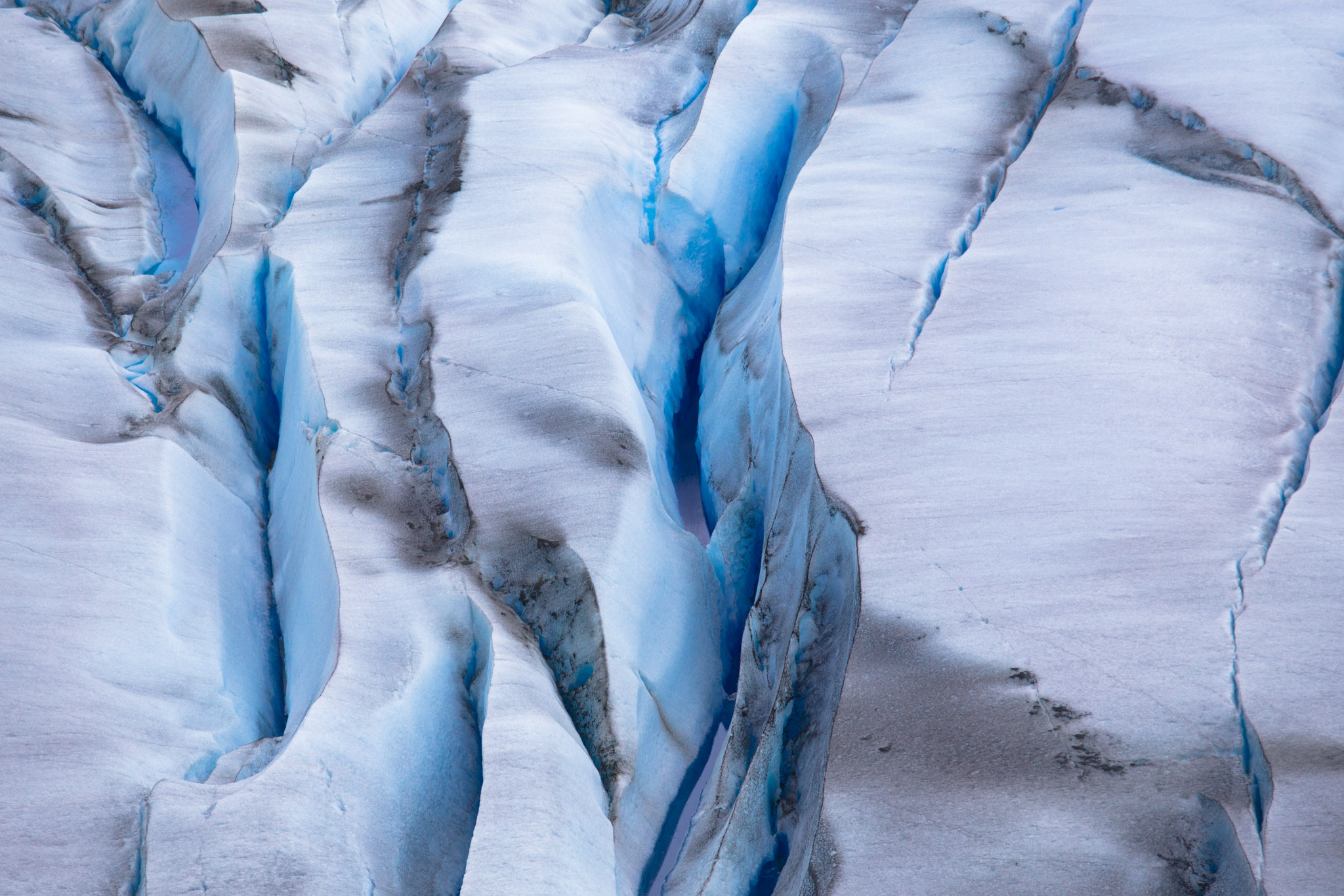
Given the cloudy vista and slight fatigue we opt for the second option, reassured by the 45 minute one way time estimate. What the map neglected to properly explain was there are in fact two hike options for the glacier and if one is to follow the sign posts on the path pointing to the lake rather than the glacier then they are in for a 3.5 hour hike requiring one to scale massive boulders, make ill advised leaps over large crevices and fjord fast flowing rivers. Guess which one we took. There were tears. Often in situations like this I will look back and say it was worth it. Not this time, by the time we got there the clouds were obscuring much of the glacier and the wind was blowing over the lake. We heard many loud rumbles of falling ice but only managed to see one small cascade. It was pretty but I was exhausted. On the plus side we slept really well that night!

The next day promised to be easier. After a lazy morning and a fortifying breakfast of porridge we set off for the Laguna Torre, situated at the base of the Cerro Torre and glacier. It was a pleasant hike through meadows and Fagus forests and finally down to the floor of the valley carved by the glacier we were heading to. Glacier valleys are interesting things, littered with enormous boulders spat out by the retreating ice. As one approaches the remaining ice mass the vegetation gives way to rocky scree fields scattered with multi veined frigid rivers, like a Martian landscape too hostile to support significant levels of plant life. It was here that we camped for the night in a newly sprouted group of Fagus trees at the base of the glacier. Once again clouds thwarted our views of the mountains yet made for fascinating viewing as they swirled, shifted and disappeared only to regenerate over the peaks.    

Our final day lead us back to El Chalten. As condors soared over the valley we frequently looked behind in the hope of a clear view. Finally about half way back we got our first clear view of Cerro Torre, a little late but better than never. At the last mirador we had great views over the whole range with both towers in view and a couple of condors thrown in for good measure. We arrived back in town in time for lunch just as the wind really picked up. There was just enough time to pitch our tent in a protected nook of the campground before it started to rain (horizontally). Perhaps our recent trekking endeavours have encouraged the hiking gods to look upon us favourably.

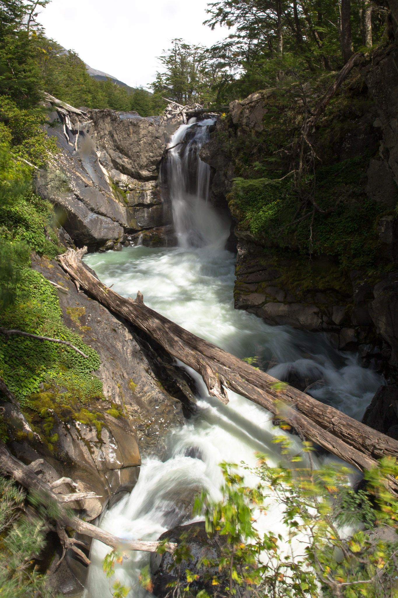
A pleasant hike to a nearby waterfall the next day left us feeling like we had done El Chalten, the capital of hiking, justice. As it turns out this was our last stop in Patagonia. For now.

Torres del Paine, Chile - Part 2

We awoke at 3am on the final day of the our hike through the Torres del Paine National Park. Our tent neighbours having finally quietened down around midnight. Our objective, to perform the pilgrimage of lights up the trail to see the Torres del Paine at sunrise.

An hour before sunrise, with a full moon just setting providing an outlining glow of the Torres del Paine.

It is a 2hr hike up the mountain to the mirador, a lake overlooking the Torres. We appear to be amongst the first to begin the trek but expect to be overtaken by the more eager, faster hikers. We are just happy to be hiking without the heavy backpacks we have been lugging around with us for the last 8 days.

The pilgrimage of lights

As we leave the tree line and begin scrambling over the rocky moraine I see a trail of head torches below us. It strikes me as an odd pilgrimage we find ourselves on, a shared purpose where we decide to brave the early morning cold for a glimpse of some mountains.

The lights are also growing closer, the clack-clack of Mr. Travel with his walking sticks grows louder. We are overtaken by the first wave of hikers but are still amongst the first to arrive at the mirador.

After finding a nice spot with potential for reflections from the lake (if only the wind would die down) we await sunrise. And wait. Turns out the lady at the campsite either appreciates the very pre-dawn aspect of the sunrise or has not updated her advice since the summer solstice. We waited for over one and a half hours in the cold. A hiker sets up on a nearby rock, unrolling his mattress and snuggling into a sleeping bag while we watch on with obvious envy. We wait a little longer.

Waiting for sunrise at the mirador

Our reward is a perfectly clear sky as the sun rises and shines a deep red glow over the Torres. As the mountains grew a bright red an Andean Condor flew into view, finally settling on his nest up high in the mountain. This is one of the iconic photos of the Torres del Paine National Park and a good way to complete our hike. On our way to the bus we descend approximately 950m, not at all envious of the day hikers we pass heading up the hill hoping to get to the mirador and back in a single day. We are ready for some well deserved R&R.

The Torres del Paine at sunrise

Torres del Paine, Chile

Towers of Pain(e)

The Torres del Paine National Park is located in Chilean Patagonia. It is characterised by towering mountains and even taller cloud formations, vibrant blue lakes and an impressive ice sheet that terminates as the Grey Glacier. The park is ideal for hiking, the two most famous trekking trails are the 'W' and the 'O'. The 'W' being a 5 day subset of the 9 day 'O' trail.

View from the Paine Grande campsite.

View from the Paine Grande campsite.

After arriving in Puerto Natales with our two new hiking buddies Shannan set about organising provisions for the 9 day adventure around the 'O' circuit or, as it's called on the official maps, 'circuit paine', an apt name. Quite a significant amount of food weighed down our packs as we set off. At least this would only get lighter over the following days, giving us the illusion of increasing strength and fitness.

Giving vivid meaning to 'bed bugs' this critter was apparently a victim of my rolling about in a sleeping bag. 

Giving vivid meaning to 'bed bugs' this critter was apparently a victim of my rolling about in a sleeping bag. 

Campsites varied in price and features from free and basic (one where a visit to the toilet involved the judicial and well balanced use of a rope, I was less than impressed) to paid sites run by private companies varying between 4000CP to 6000CP, again with varying levels of facilities. All paid sites technically provide hot showers etc. but sometimes they were limited to a 2hr window of hot water and other times there were only 2 showers for an already overcrowded campsite, both leading to Soviet Russia style queuing for the limited resources. The campsite locations were usually somewhere spectacular with a short walk to a waterfall or icebergs floating near glacier faces or a 180 degree view of the ice sheet itself. This had the tendency to mollify any of our grumping. Besides, where is Australia do you get even the promise of a hot shower and a morning coffee mid-hike?

The hike itself made sure to throw us a number of challenges to distract us from the postcard scenery encountered at every turn. Day 4 is well remembered by all, this day saw us climbing to over 1200masl over rocky glacier deposits into a headwind gusting to excess of 100km/hr. The wind would change directions making it hard to brace your position, the backpack acting as a sail. Even when braced the gusts could literally move the ground underneath as the small rocks would give way and you found yourself sliding downhill. One hiker we passed recounted being lifted off her feet and deposited, roughly, about a meter away from the path.

The following day we had the excitement of crossing two canyons with ladders held to the mountainside by ropes, the bolt holds left dangling in the air in a rather disconcerting manner. This was actually an improvement over the previous wooden ladders with occasional steps missing and ropes fraying.

Of course, all this excitement was done for the purpose of seeing the spectacular landscape of the Torres del Paine region of Patagonia and it did not disappoint. We were constantly rewarded with scenes that took our breath away and on several occasions I found myself exclaiming my excitement out loud as we burst out of the trees to a waterfall running off to a glacier that seemed superimposed where the sky should be, or scrambling over rocks to a summit and seeing ice melt flowing between immense blue icebergs.

The texture of the glacier as we walked alongside it was amazing. The weather was not always conducive to capturing it (water on the lens being a constant nemesis) however the following images manage to capture some of the curves, shades and vivid blues that were our companion for 2 days of hiking, either in a sweeping vista or poking through the trees in a surreal fashion. Its difficult to show perspective, but these crevasses were tens of metres deep.

At the End of the World

Apologies about the lack of updates recently.

We are in Ushuaia, Argentina, the southern most town in the world. Satellite dishes here appear to be aimed into the ground and we have daily highs of around 10C or less in the peak of summer. We don't really see night time at all, it's sunshine when we wake up and still shining when we go to sleep in our tent.

The wifi is spotty at best and I am unable to upload photos (I feel, a key part of the blog). There are posts coming from Uruguay, Buenos Aires and the regions around Ushuaia so stay tuned!